Line 4 of the Paris Metro
Version: January 2025Line 4 was the first line of the Paris Metro to be completely underground from north to south. It is also notable for connecting with more metro lines than any other in the network, facilitating cross-city travel in multiple directions.
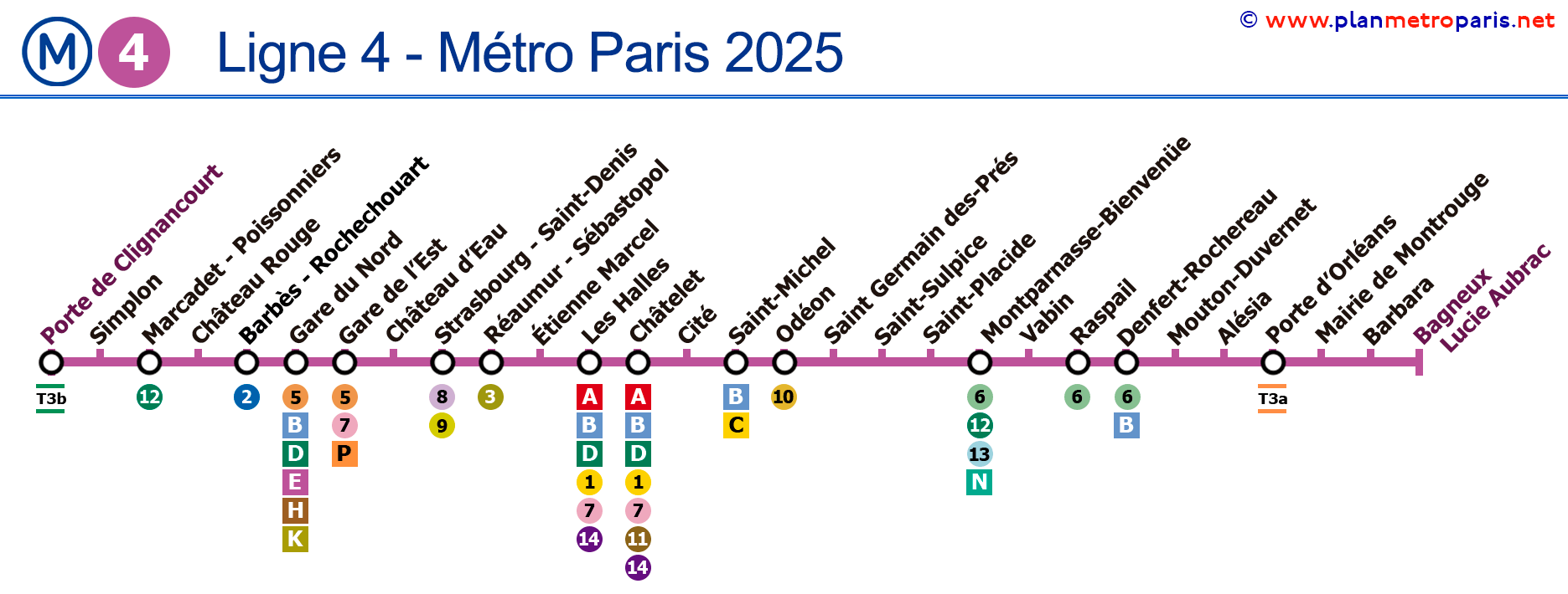
Map of Line 4
See the stations on the map below (as of January 2025):
→ Click to enlarge ←

General Data
Description of Line 4 of the Paris Metro:
- Inaugurated in 1908, it was one of the last lines of the initial metro network plan.
- Colour: Magenta.
- Traverses the city from north to south and was the first to cross the River Seine underground.
- The line has 27 stations and was extended to Bagneux-Lucie Aubrac in 2022.
- Total track length of approximately 13.9 km (8.6 miles).
Historical and Current Curiosities
Interesting facts about Line 4 of the Paris Metro:
- Line 4 connects with all Paris Metro lines except Lines 3bis and 7bis, and with all five RER lines.
- It is one of the busiest lines in the system, with a significant daily passenger count.
- It was the first line of the Paris Metro to be automated, with driverless trains starting operations in 2022.
- Line 4 also serves three of Paris's train stations: Gare du Nord, Gare de l'Est, and Gare Montparnasse.
- The Cité station offers a special atmosphere with its green lights reflecting off the white tiles of the station, creating an almost sci-fi ambiance.
- Line 4 has stops that take you to some of the most iconic places in Paris, including the Île de la Cité, home to Notre Dame Cathedral, the Sainte-Chapelle, and the Palais de Justice.
- The extension to Bagneux-Lucie Aubrac in 2022 further connects the metro network to the future expansion of the Grand Paris Express.
- The Line 4 stations are also notable for their cultural heritage, such as the historic Luxor cinema at Barbès-Rochechouart with decorations inspired by ancient Egyptian architecture.
If you wish, you can view the complete map of the Paris Metro here, a page with all lines grouped (but separated, one by one), or view multiple lines simultaneously.
Station List of Line 4
Here is the list of metro stops for Line 4 of the Paris Metro. If you click on the line icons, you will see information about that line and its transfers.
Route: Porte de Clignancourt - Bagneux/Lucie Aubrac
Y eso es todo, te agradecemos tu visita y tu confianza en nosotros y esperamos que hayas encontrado útil el mapa de la Línea 4 del Metro de París.
Paris Metro Map | Timetables | Fares | All Metro Lines