Line 13 of the Paris Metro
Version: January 2025Known for being one of the most congested lines in the Paris Metro system, Line 13 splits into two branches in its northern section, often causing confusion and large crowds, especially during peak hours.
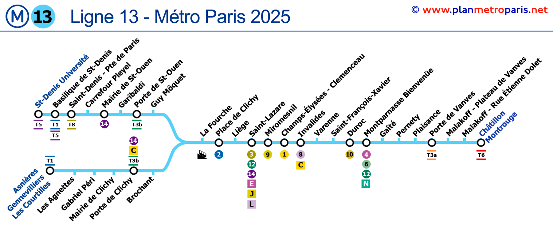
Map of Line 13
See the stations on the map below (January 2025).

General Data
Description of Line 13 of the Paris Metro:
- Initially inaugurated in 1911, later extended in 1976.
- Colour: Light blue.
- Combines underground sections with surface-level sections.
- 32 stations, with a route that branches into two different directions in its northern section.
- Total track length of approximately 24.3 km (15.1 miles).
Historical and Current Curiosities
- Line 13 originally operated as Line B of the Nord-Sud company, before being renamed Line 13 after Nord-Sud merged with CMP in 1930.
- It is known for its overcrowding due to the high population density in the areas it serves, making it one of the most congested lines in the Paris Metro system.
- Interesting cultural and tourist points near several Line 13 stations include the Basilica of Saint-Denis, famous as the necropolis of the Kings of France, and the pet cemetery in Asnières-sur-Seine, one of the most unusual in the world.
- Saint-Lazare station on Line 13 is a major transport hub, offering access to various department stores and tourist attractions such as the Champs-Élysées and the Louvre Museum.
- Liège station, originally called "Berlin," was renamed in 1914 and is decorated with ceramic murals depicting landscapes from the province of Liège.
If you wish to explore the entire network, we invite you to view the complete Paris Metro Map. This resource includes a page where all the lines are presented in an organised manner (though separated), or you can choose to examine individual lines on a single page.
List of Stations and Routes of Line 13
Clicking on the line icons will provide information about that line and its transfers.
Route: Asnières/Gennevilliers/Les Courtilles - Châtillon/Montrouge
Paris Metro Map | Timetables | Fares | All Metro Lines